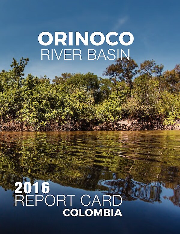
Orinoco River Basin Report Card 2016
This report card provides a transparent, timely, and geographically detailed assessment of the Orinoco River Basin. In 2016, the report card includes eleven indicators in the categories of Biodiversity, Management & Governance, Ecosystems & Landscapes, Economy, People & Culture, and Water. In 2016, the overall grade for the Orinoco River Basin is a 63%, a B-. This means the Orinoco is in moderately good health. In addition to the overall Orinoco's report card, there are ten sub-basin report cards that provide further details for specific sub-basins.
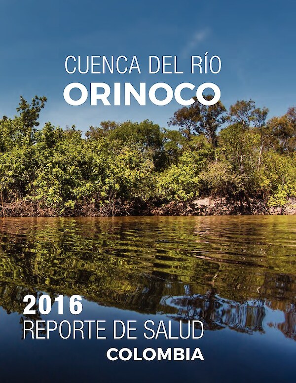
Cuenca del rio Orinoco Reporte de Salud 2016
Este reporte de salud provee una evaluación transparente, oportuna y geográficamente detallada de la cuenca del río Orinoco. Para el año 2016, el reporte incluye once indicadores bajo las categorías de Biodiversidad, Manejo y gobernanza, Ecosistemas y paisaje, Economía, Gente y cultura, y Agua. En el 2016, la calificación global para la cuenca del río Orinoco fue de 63% o B-. Esto indica que el Orinoco cuenta con una salud moderadamente buena. Adicional al reporte general de la cuenca del río Orinoco, existen reportes individuales para diez sub-cuencas que proveen información detallada.
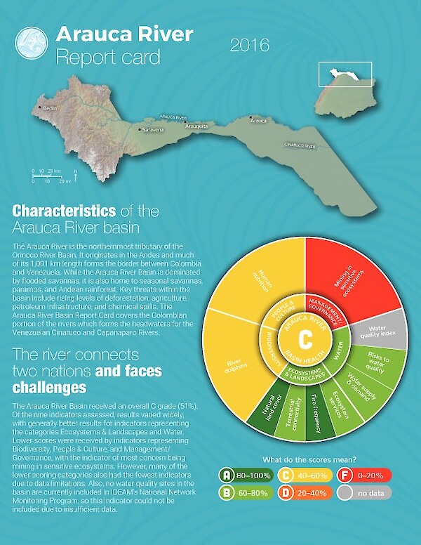
Arauca River Report Card 2016
This report card provides a transparent, timely, and geographically detailed assessment of the Arauca River, a sub-basin in the Orinoco River Basin. In 2016, the overall grade for the Arauca River is a 51%, a C. This means the Arauca is in moderate health.
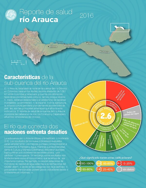
Reporte de salud río Arauca 2016
Este reporte de salud provee una evaluación transparente, oportuna y geográficamente detallada del río Arauca, que es una de las sub-cuencas del río Orinoco. En 2016, la calificación global para el río Arauca es de 2.6. Esto significa que el Arauca cuenta con una salud moderada.
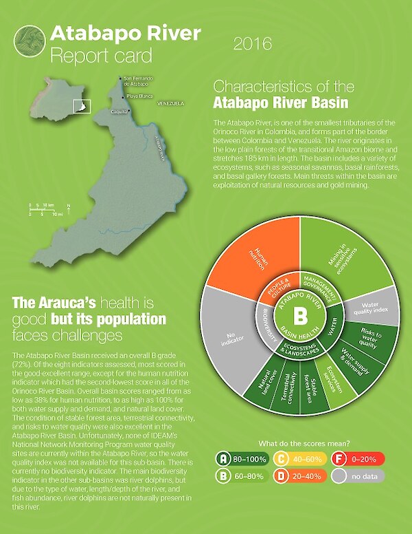
Atabapo River Report Card 2016
This report card provides a transparent, timely, and geographically detailed assessment of the Atabapo River, a sub-basin in the Orinoco River Basin. In 2016, the overall grade for the Atabapo River is a 72%, a B. This means the Arauca is in moderately good health.
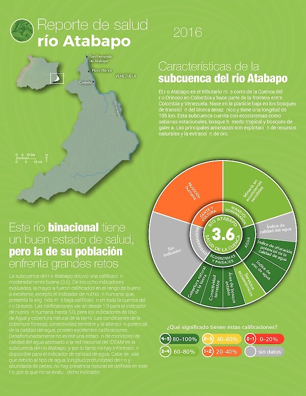
Reporte de salud río Atabapo 2016
Este reporte de salud provee una evaluación transparente, oportuna y geográficamente detallada del río Atabapo, que es una de las sub-cuencas del río Orinoco. En 2016, la calificación global para el río Atabapo es de 3.6. Esto significa que el Atabapo cuenta con una salud moderadamente buena.
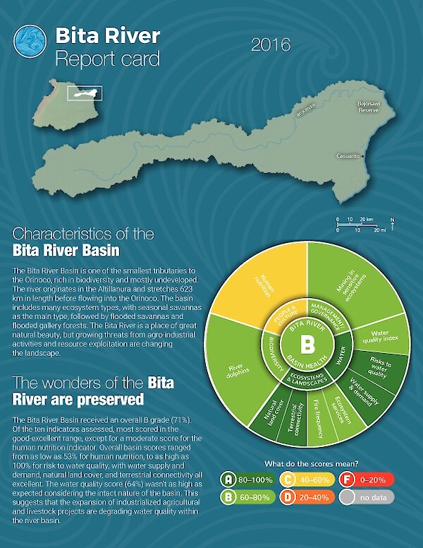
Bita River Report Card 2016
This report card provides a transparent, timely, and geographically detailed assessment of the Bita River, a sub-basin in the Orinoco River Basin. In 2016, the overall grade for the Bita River is a 71%, a B. This means the Bita is in moderately good health.
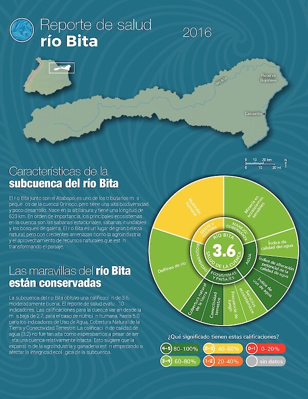
Reporte de salud río Bita 2016
Este reporte de salud provee una evaluación transparente, oportuna y geográficamente detallada del río Bita, que es una de las sub-cuencas del río Orinoco. En 2016, la calificación global para el río Bita es de 3.6. Esto significa que el Bita cuenta con una salud moderadamente buena.
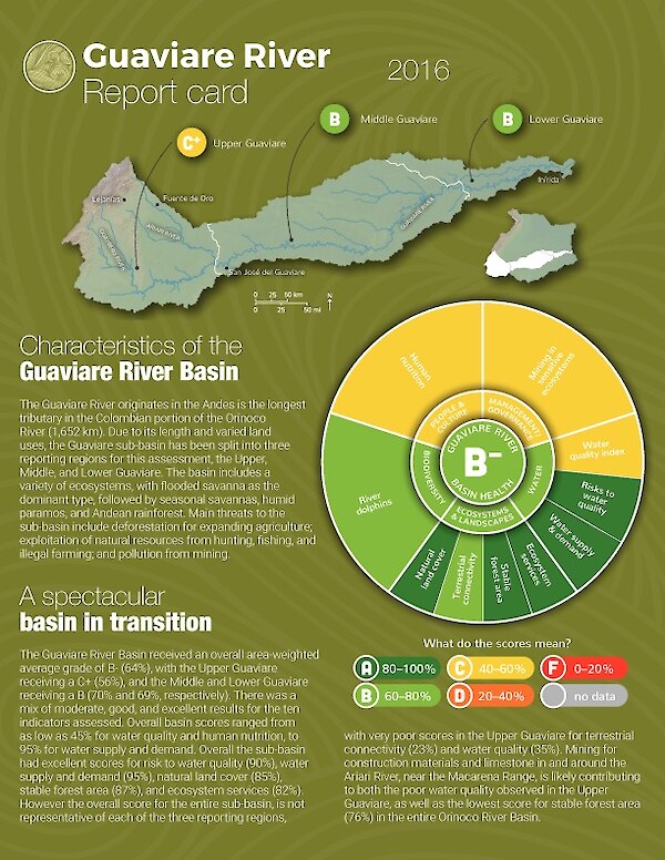
Guaviare River Report Card 2016
This report card provides a transparent, timely, and geographically detailed assessment of the Guaviare River, a sub-basin in the Orinoco River Basin. In 2016, the overall grade for the Guaviare River is a 64%, a B-. This means the Guaviare is in moderately good health.
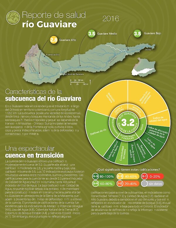
Reporte de salud río Guaviare 2016
Este reporte de salud provee una evaluación transparente, oportuna y geográficamente detallada del río Guaviare, que es una de las sub-cuencas del río Orinoco. En 2016, la calificación global para el río Guaviare es de 3.2. Esto significa que el Guaviare cuenta con una salud moderadamente buena.
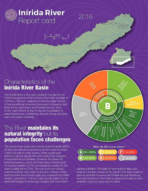
Inirida River Report Card 2016
This report card provides a transparent, timely, and geographically detailed assessment of the Inírida River, a sub-basin in the Orinoco River Basin. In 2016, the overall grade for the Inírida River is a 68%, a B. This means the Inírida is in moderately good health.
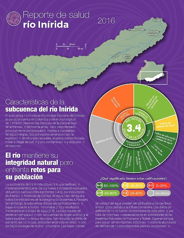
Reporte de salud río Inírida 2016
Este reporte de salud provee una evaluación transparente, oportuna y geográficamente detallada del río Inírida, que es una de las sub-cuencas del río Orinoco. En 2016, la calificación global para el río Inírida es de 3.4. Esto significa que el Inírida cuenta con una salud moderadamente buena.
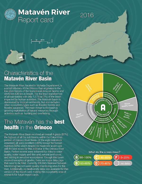
Matavén River Report Card 2016
This report card provides a transparent, timely, and geographically detailed assessment of the Matavén River, a sub-basin in the Orinoco River Basin. In 2016, the overall grade for the Matavén River is a 87%, an A. This means the Matavén is in good health.
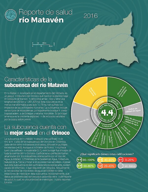
Reporte de salud río Matavén 2016
Este reporte de salud provee una evaluación transparente, oportuna y geográficamente detallada del río Matavén, que es una de las sub-cuencas del río Orinoco. En 2016, la calificación global para el río Matavén es de 4.4. Esto significa que el Matavén cuenta con una salud buena.
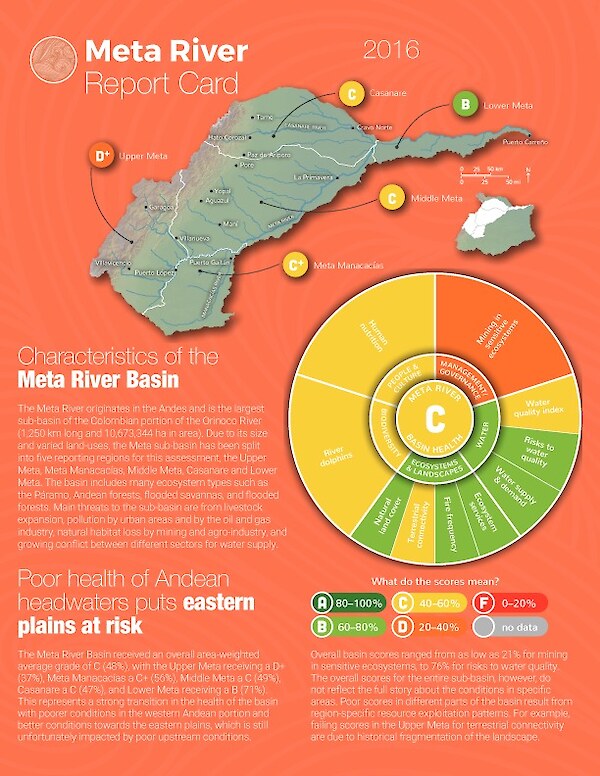
Meta River Report Card 2016
This report card provides a transparent, timely, and geographically detailed assessment of the Meta River, a sub-basin in the Orinoco River Basin. In 2016, the overall grade for the Meta River is a 48%, a C. This means the Meta is in moderate health.
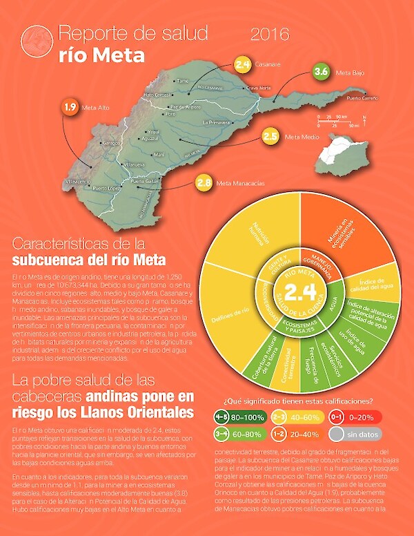
Reporte de salud río Meta 2016
Este reporte de salud provee una evaluación transparente, oportuna y geográficamente detallada del río Meta, que es una de las sub-cuencas del río Orinoco. En 2016, la calificación global para el río Meta es de 2.4. Esto significa que el Meta cuenta con una salud moderada.
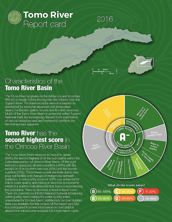
Tomo River Report Card 2016
This report card provides a transparent, timely, and geographically detailed assessment of the Tomo River, a sub-basin in the Orinoco River Basin. In 2016, the overall grade for the Tomo River is a 84%, an A-. This means the Tomo is in good health.
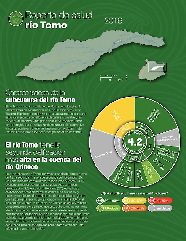
Reporte de salud río Tomo 2016
Este reporte de salud provee una evaluación transparente, oportuna y geográficamente detallada del río Tomo, que es una de las sub-cuencas del río Orinoco. En 2016, la calificación global para el río Tomo es de 4.2. Esto significa que el Tomo cuenta con una salud buena.
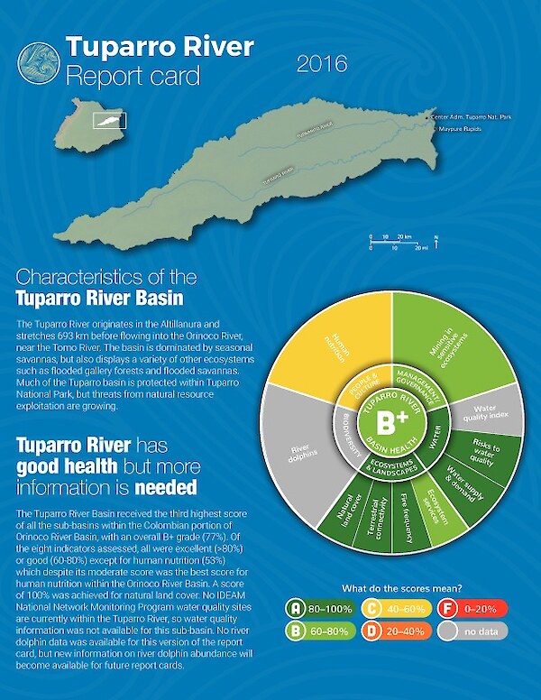
Tuparro River Report Card 2016
This report card provides a transparent, timely, and geographically detailed assessment of the Tuparro River, a sub-basin in the Orinoco River Basin. In 2016, the overall grade for the Tuparro River is a 77%, a B+. This means the Tuparro is in moderately good health.
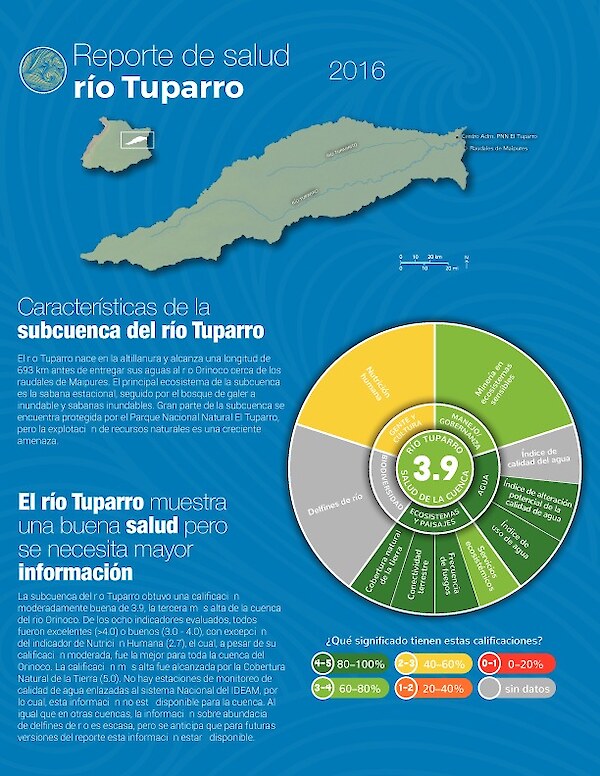
Reporte de salud río Tuparro 2016
Este reporte de salud provee una evaluación transparente, oportuna y geográficamente detallada del río Tuparro, que es una de las sub-cuencas del río Orinoco. En 2016, la calificación global para el río Tuparro es de 3.9. Esto significa que el Tuparro cuenta con una salud moderadamente buena.
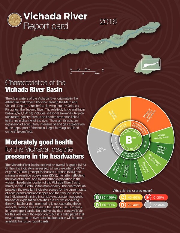
Vichada River Report Card 2016
This report card provides a transparent, timely, and geographically detailed assessment of the Vichada River, a sub-basin in the Orinoco River Basin. In 2016, the overall grade for the Vichada River is a 61%, a B-. This means the Vichada is in moderately good health.

Reporte de salud río Vichada 2016
Este reporte de salud provee una evaluación transparente, oportuna y geográficamente detallada del río Vichada, que es una de las sub-cuencas del río Orinoco. En 2016, la calificación global para el río Vichada es de 3.1. Esto significa que el Vichada cuenta con una salud moderadamente buena.