EcoHealth Report Cards
  • About
  • The Process
  • Contact
  • Report Cards
    • Chesapeake Bay
    • Clinton River
    • Detroit River
    • Guanabara Bay
    • Huron River
    • Lake Erie
    • Long Island Sound
    • Maryland Coastal Bays
    • Orinoco River
    • Rio Grande
    • River Raisin
    • Rouge River
    • Southeast Michigan
    • Sudbury, Assabet, & Concord Rivers
    • Verde River
    • Willamette River

Orinoco River

  • Home
  • Health
  • Indicators
    • Water Quality Index
    • Risks to Water Quality
    • Water Supply and Demand
    • Natural Land Cover
    • Stable Forest Area
    • Terrestrial Connectivity
    • Fire Frequency
    • Ecosystem Services
    • Human Nutrition
    • Mining in Sensitive Ecosystems
    • River Dolphins
  • Regions
    • Arauca River
    • Atabapo River
    • Bita River
    • Guaviare River
    • Inírida River
    • Matavén River
    • Meta River
    • Tomo River
    • Tuparro River
    • Vichada River
  • Issues
  • Publications
  • About
  1. Home
  2. Report Cards
  3. Orinoco River
  4. Regions
  5. Matavén River

Matavén River

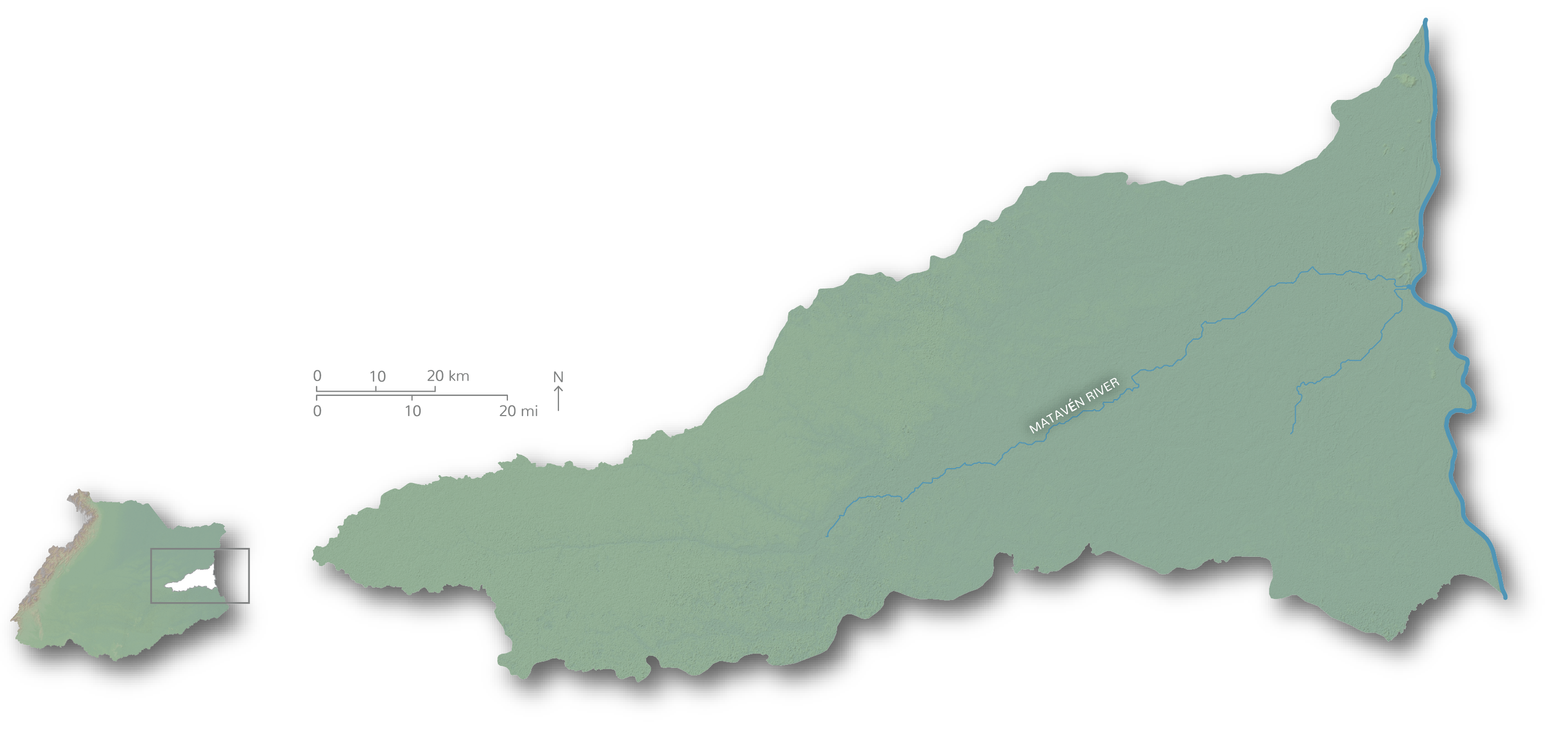
Characteristics of the Matavén River Basin

The Matavén River, located in Vichada Department, is a small tributary of the Orinoco that originates in the low plain forests of the transitional Amazon biome and stretches 630 km in length. It is the least transformed of all sub-basins with only 1,173 ha (1%) of the basin impacted by human activities. The Matavén basin is dominated by tropical rainforests, but also includes other ecosystem types such as flooded forests and flooded savannas. The main threat to the basin is growing exploitation of natural resources through activities such as hunting and overfishing.

The Matavén has the best health in the Orinoco

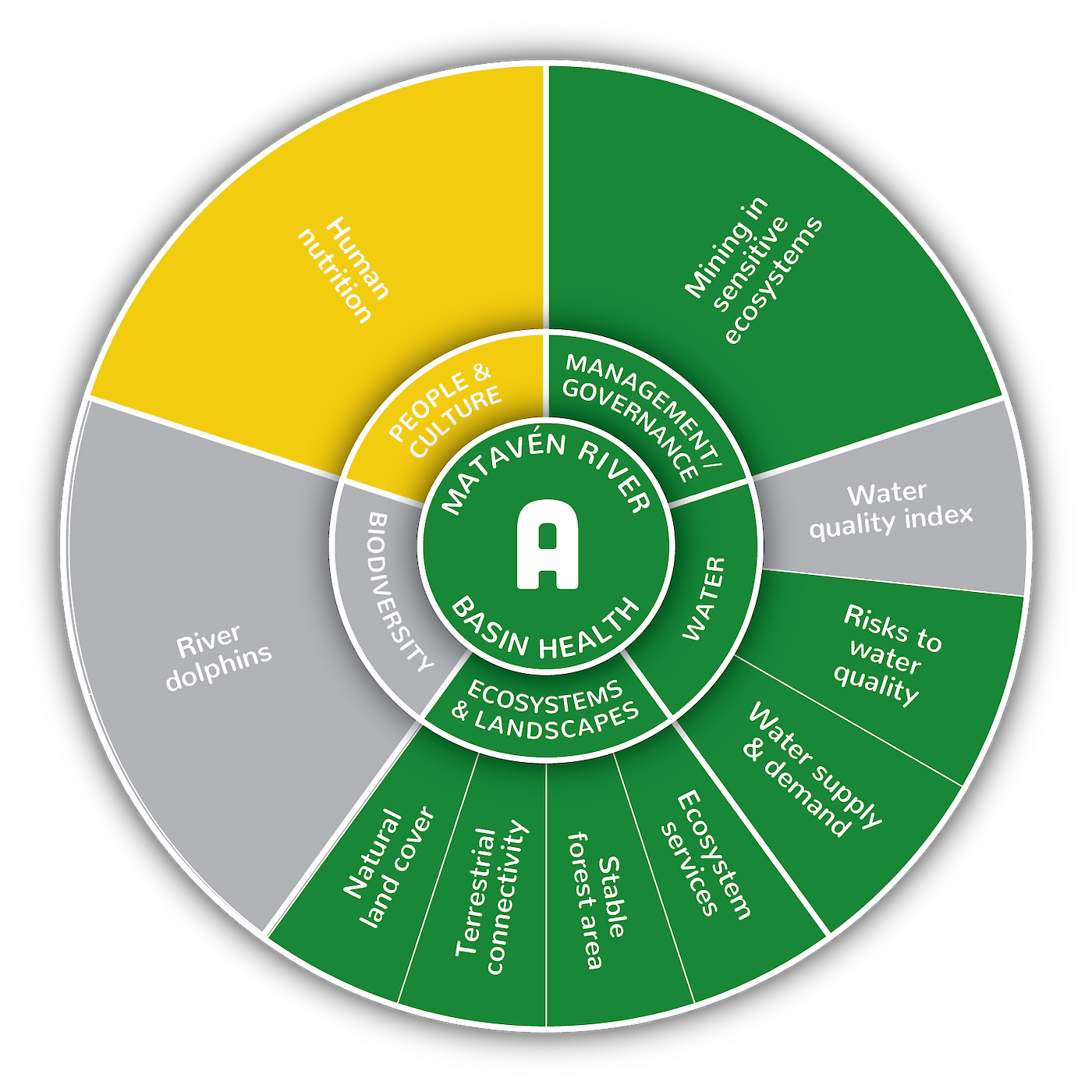
The Matavén River Basin received an overall A grade (87%), the highest of all the sub-basins within the Colombian portion of Orinoco River Basin. Of the eight indicators assessed, all were excellent (>80%) except for human nutrition (53%) which despite its moderate score was still the best score for this indicator in the Orinoco River Basin. Perfect scores were achieved for risks to water quality, water supply and demand, natural land cover, and mining in sensitive ecosystems. Though this basin received exceptional grades, there are major data gaps that need to be filled. Currently IDEAM’s National Network Monitoring has not water quality monitoring sites for the river. Additionally, no biodiversity data was available for this version of the report card, making this is a priority area of research for future report cards.

In this section

  • Regions
    • Arauca River
    • Atabapo River
    • Bita River
    • Guaviare River
    • Inírida River
    • Matavén River
    • Meta River
    • Tomo River
    • Tuparro River
    • Vichada River

© 2025 UMCES

  • Home
  • About
  • The Process
  • Contact
  • Report Cards
    • Chesapeake Bay
      • Bay Health
      • Watershed Health
      • Indicators
        • Overall Health Index
        • Dissolved Oxygen
        • Nitrogen
        • Phosphorus
        • Turbidity
        • Water Quality Index
        • Chlorophyll a
        • Water Clarity
        • Conductivity
        • Aquatic Grasses
        • Benthic Community
        • Fish community
        • Temperature Stress
        • Protected Lands
        • Social Index
        • Walkability
        • Heat Vulnerability Index
        • Household income
        • Affordable housing
        • Income equality
        • Jobs growth
      • Bay Regions
        • Lower Eastern Shore
        • Choptank River
        • Upper Eastern Shore
        • Upper Western Shore
        • Patapsco and Back Rivers
        • Lower Western Shore
        • Patuxent River
        • Potomac River
        • Rappahannock River
        • York River
        • James River
        • Elizabeth River
      • Watershed Regions
        • Overall
        • Chemung
        • Choptank
        • Elizabeth
        • Juniata
        • Lower Eastern Shore
        • Lower James
        • Lower Potomac
        • Lower Susquehanna
        • Lower Western Shore
        • Middle James
        • Middle Potomac
        • Middle Susquehanna
        • Patapsco and Back
        • Patuxent
        • Rappahannock
        • Shenandoah
        • Upper Eastern Shore
        • Upper James
        • Upper Potomac
        • Upper Susquehanna
        • Upper Western Shore
        • West Branch Susquehanna
        • York
      • Issues
        • 2024
        • 2023
        • 2022
        • 2021
        • 2020
        • 2019
        • 2018
        • 2017
        • 2016
        • 2015
        • 2014
        • 2013
        • 2012
        • 2011
        • 2010
        • 2009
        • 2008
        • 2007
        • 2006
      • Publications
      • Take Action
      • About
    • Clinton River
      • Health
      • Indicators
        • Overall Health Index
        • Household Income
        • Local Ownership
        • Cost of Flooding
        • Income Equality
        • Trade
        • River Economy
        • Wetlands
        • Tree Cover
        • Forests
        • Fish Populations
        • Bird Diversity
        • Benthic Community
        • Protected Lands
        • Fish Consumption
        • Bacteria
        • Heat Vulnerability
        • Air Quality Index
        • Environmental Justice
        • Flooding
        • Sewer Overflows
        • Impervious Surfaces
        • Farmland
        • Affordable Housing
        • Walkability
        • Parks
        • Beach Access
        • Watercraft Access
        • Fishing
        • Nitrogen
        • Phosphorus
        • Dissolved Oxygen
        • Water Temperature
        • Turbidity
      • Region
        • Clinton River
      • Issues
      • Publications
      • About
    • Detroit River
      • Health
      • Indicators
        • Overall Health Index
        • Household Income
        • Local Ownership
        • Cost of Flooding
        • Income Equality
        • Trade
        • River Economy
        • Wetlands
        • Tree Cover
        • Forests
        • Fish Populations
        • Bird Diversity
        • Benthic Community
        • Protected Lands
        • Fish Consumption
        • Bacteria
        • Heat Vulnerability
        • Air Quality Index
        • Environmental Justice
        • Flooding
        • Sewer Overflows
        • Impervious Surfaces
        • Farmland
        • Affordable Housing
        • Walkability
        • Parks
        • Beach Access
        • Watercraft Access
        • Fishing
        • Nitrogen
        • Phosphorus
        • Dissolved Oxygen
        • Water Temperature
        • Turbidity
      • Region
        • Detroit River Watershed
      • Issues
      • Publications
      • About
    • Guanabara Bay
      • Bay Health
      • Basin Health
      • Indicators
        • Overall Health Index
        • Dissolved Oxygen
        • Biological Oxygen Demand
        • Dissolved Inorganic Nitrogen
        • Total Phosphorus
        • Orthophosphate
        • Turbidity
        • Fecal coliform
      • Sanitation
      • Issues
      • Publications
      • About
    • Huron River
      • Health
      • Indicators
        • Overall Health Index
        • Household Income
        • Local Ownership
        • Cost of Flooding
        • Income Equality
        • Trade
        • River Economy
        • Wetlands
        • Tree Cover
        • Forests
        • Fish Populations
        • Bird Diversity
        • Benthic Community
        • Protected Lands
        • Fish Consumption
        • Bacteria
        • Heat Vulnerability
        • Air Quality Index
        • Environmental Justice
        • Flooding
        • Sewer Overflows
        • Impervious Surfaces
        • Farmland
        • Affordable Housing
        • Walkability
        • Parks
        • Beach Access
        • Watercraft Access
        • Fishing
        • Nitrogen
        • Phosphorus
        • Dissolved Oxygen
        • Water Temperature
        • Turbidity
      • Region
        • Huron River
      • Issues
      • Publications
      • About
    • Lake Erie
      • Lake Health
      • Watershed Health
      • Indicators
        • Overall Health Index
        • Total Phosphorus
        • Dissolved Phosphorus
        • Total Nitrogen
        • Nitrate + Nitrite
        • Chlorophyll a
        • Walleye
        • Yellow Perch
        • Emerald Shiner
        • Bloom Index
        • Source Water Toxin
        • Recreational Toxin
        • Total Suspended Solids
        • Fish
        • Macroinvertebrates
        • Habitat Quality
        • Fish Consumption
        • Pesticide
      • Lake Regions
        • Overall Lake
        • Northwest
        • Southwest
        • Maumee
        • Northeast
        • Eastern Islands
        • Sandusky Bay
      • Watershed Regions
        • Overall Watershed
        • Auglaize
        • Cedar/Portage
        • Detroit
        • Essex
        • Raisin/Huron
        • St. Joseph
        • St. Marys
        • Lower Maumee
        • Lower Thames
        • Sandusky
        • Tiffin
        • Upper Maumee
        • Upper Thames
      • Issues
      • Publications
      • Take Action
      • About
    • Long Island Sound
      • Health
      • Indicators
        • Overall Health Index
        • Dissolved Oxygen
        • Chlorophyll a
        • Water Clarity
        • Dissolved Organic Carbon
      • Regions
        • Overall
        • Western Narrows
        • Eastern Narrows
        • Western Basin
        • Central Basin
        • Eastern Basin
      • Issues
        • 2018
        • 2015
        • 2013
      • Publications
      • Take Action
      • About
    • Maryland Coastal Bays
      • Health
      • Indicators
        • Overall Health Index
        • Chlorophyll a
        • Dissolved Oxygen
        • Nitrogen
        • Phosphorus
        • Seagrass
        • Hard Clams
      • Regions
        • Overall
        • Assawoman Bay
        • Chincoteague Bay
        • Isle of Wight Bay
        • Newport Bay
        • Sinepuxent Bay
        • St. Martin River
      • Issues
        • 2023
        • 2022
        • 2021
        • 2019
        • 2018
        • 2017
        • 2016
        • 2015
      • Publications
      • Take Action
      • About
    • Orinoco River
      • Health
      • Indicators
        • Water Quality Index
        • Risks to Water Quality
        • Water Supply and Demand
        • Natural Land Cover
        • Stable Forest Area
        • Terrestrial Connectivity
        • Fire Frequency
        • Ecosystem Services
        • Human Nutrition
        • Mining in Sensitive Ecosystems
        • River Dolphins
      • Regions
        • Arauca River
        • Atabapo River
        • Bita River
        • Guaviare River
        • Inírida River
        • Matavén River
        • Meta River
        • Tomo River
        • Tuparro River
        • Vichada River
      • Issues
      • Publications
      • About
    • Rio Grande
      • Health
      • Indicators
        • Overall Health Index
        • Annual low flow
        • Zero Flow Days
        • Municipal Water Supply
        • Groundwater
        • Agriculture surface water supply
        • Flow Alteration
        • Riparian Areas
        • Water Supply for Compact
        • Impaired Streams
        • Invasive Trees and Shrubs
        • Wetland Loss
        • Bird Diversity
        • Silvery Minnow
        • Native Fish Diversity
        • All Fish Diversity
        • Native peoples and acequias support
        • Native peoples and acequias representation
        • Water Resource Governance
        • Water Resource Management
        • Protected Lands
        • Fire
        • Park Visitation
        • Recreation Access
        • Cultural and Historical Places
        • Walkability
        • Heat Vulnerability Index
        • Social Vulnerability Index
        • Air Quality
        • Affordable Housing
      • Regions
        • Overall
        • Upper Rio Grande - CO
        • Upper Rio Grande - NM
        • Middle Rio Grande
        • Lower Rio Grande
      • Issues
      • Publications
      • About
    • River Raisin
      • Health
      • Indicators
        • Overall Health Index
        • Household Income
        • Local Ownership
        • Cost of Flooding
        • Income Equality
        • Trade
        • River Economy
        • Wetlands
        • Tree Cover
        • Forests
        • Fish Populations
        • Bird Diversity
        • Benthic Community
        • Protected Lands
        • Fish Consumption
        • Bacteria
        • Heat Vulnerability
        • Air Quality Index
        • Environmental Justice
        • Flooding
        • Sewer Overflows
        • Impervious Surfaces
        • Farmland
        • Affordable Housing
        • Walkability
        • Parks
        • Beach Access
        • Watercraft Access
        • Fishing
        • Nitrogen
        • Phosphorus
        • Dissolved Oxygen
        • Water Temperature
        • Turbidity
      • Region
        • River Raisin
      • Issues
      • Publications
      • About
    • Rouge River
      • Health
      • Indicators
        • Overall Health Index
        • Household Income
        • Local Ownership
        • Cost of Flooding
        • Income Equality
        • Trade
        • River Economy
        • Wetlands
        • Tree Cover
        • Forests
        • Fish Populations
        • Bird Diversity
        • Benthic Community
        • Protected Lands
        • Fish Consumption
        • Bacteria
        • Heat Vulnerability
        • Air Quality Index
        • Environmental Justice
        • Flooding
        • Sewer Overflows
        • Impervious Surfaces
        • Farmland
        • Affordable Housing
        • Walkability
        • Parks
        • Beach Access
        • Watercraft Access
        • Fishing
        • Nitrogen
        • Phosphorus
        • Dissolved Oxygen
        • Water Temperature
        • Turbidity
      • Region
        • Rouge River
      • Issues
      • Publications
      • About
    • Southeast Michigan
      • Health
      • Indicators
        • Overall Health Index
        • Household Income
        • Local Ownership
        • Cost of Flooding
        • Income Equality
        • Trade
        • River Economy
        • Wetlands
        • Tree Cover
        • Forests
        • Fish Populations
        • Bird Diversity
        • Benthic Community
        • Protected Lands
        • Fish Consumption
        • Bacteria
        • Heat Vulnerability
        • Air Quality Index
        • Environmental Justice
        • Flooding
        • Sewer Overflows
        • Impervious Surfaces
        • Farmland
        • Affordable Housing
        • Walkability
        • Parks
        • Beach Access
        • Watercraft Access
        • Fishing
        • Nitrogen
        • Phosphorus
        • Dissolved Oxygen
        • Water Temperature
        • Turbidity
      • Regions
        • Overall
        • Clinton
        • Detroit
        • Huron
        • Raisin
        • Rouge
      • Issues
      • Publications
      • About
    • Sudbury, Assabet, & Concord Rivers
      • Health
      • Indicators
        • Overall
        • Dissolved Oxygen
        • Temperature
        • Suspended Solids
        • Phosphorus
        • Nitrogen
        • Floating Biomass
        • Streamflow Alteration
        • Groundwater Level
        • Summer Streamflow
        • Visual Quality
        • Cultural Importance
        • Impervious Cover
        • Aquatic Connectivity
        • Ecological Integrity
        • Passability
        • Access
        • Trails
        • Bacteria
        • Fish Edibility
      • Regions
        • Upper Sudbury River
        • Lower Sudbury River
        • Upper Assabet River
        • Lower Assabet River
        • Upper Concord River
        • Lower Concord River
      • Issues
      • Publications
      • Take Action
        • Discover your rivers
        • Roll up your sleeves
        • Become a citizen scientist or advocate
        • Celebrate success
      • About
    • Verde River
      • Health
      • Indicators
        • Overall Health Index
        • Base Flow
        • Surfacewater BMPs
        • Groundwater BMPs
        • Water Quality Index
        • Water Quality Certainty
        • Turbidity
        • Macroinvertebrates
        • Upland Condition Index
        • Riparian Birds
        • Fish
        • Recreation Planning
        • Visitor Satisfaction
        • Recreation Access
        • Civic Engagement
        • Digital Engagement
        • Healthcare
        • Education
        • Unemployment
        • Affordable Housing
      • Regions
        • Overall
        • Big and Little Chino
        • Upper Verde
        • Upper Verde Valley
        • Oak Creek
        • Lower Verde Valley
        • Wild and Scenic
        • Lower Verde
      • Issues
      • Publications
      • Take Action
      • About
    • Willamette River
      • Health
      • Indicators
        • Overall Health Index
        • Water Quality Index
        • Toxics
        • Temperature
        • Native Fish
        • Non-native Fish
        • Juvenile Chinook
        • Bald Eagle
        • Channel Complexity
        • Floodplain Forest
        • Flow Targets
        • Peak Flows
        • Fish Consumption Advisories
        • Tribal Fisheries
        • Fecal Bacteria
        • Harmful Algal Blooms
      • Regions
        • Upper Willamette
        • Middle Willamette
        • Lower Willamette
      • Issues
      • Publications
      • Take Action
        • Know your river
        • Make a change
        • Join the movement
        • Celebrate success
      • About