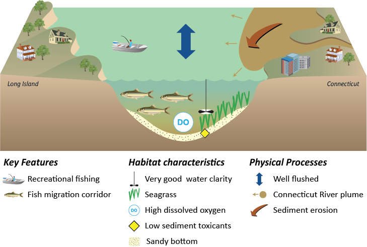
Eastern Long Island Sound is deep, with a channel, and a very small tidal range with high tidal currents. This area is very well flushed with Block Island Sound. The bottom is composed of sand to gravel and is highly scoured. The bottom waters are well oxygenated. The water is clear in Eastern Long Island Sound, and supports eelgrass beds. The land use surrounding this area is suburban to rural, but the development is the least dense. The watershed draining into Eastern Long Island Sound is dominated by the Connecticut River Watershed, which extends through Connecticut, Massachusetts, Vermont, New Hampshire, and into Quebec, Canada. Additionally, the Thames River Watershed drains into Eastern Long Island sound. There are no embayments on the Long Island side, with a sand bluff shoreline and a mostly agricultural narrow watershed on Long Island.
This reporting region extends from Central Long Island Sound to a line extending from Orient Point, Long Island and along the western shorelines of Plum, Great Gull, Little Gull and Fishers Islands to Napatree Point, Rhode Island. The body of water that this eastern boundary of Long Island Sound transits is known as ‘The Race’, a reflection of the rapid tidal currents that pass through a narrow channel between the islands and a shallow sill. The Long Island side of Eastern Long Island Sound is largely unbroken sand bluffs with no substantial embayments or rivers. The Connecticut side of Eastern Long Island Sound contains Westbrook Harbor, Oyster River, Connecticut River (the largest freshwater source for Long Island Sound, draining the largest watershed), Pattagansett River, Niantic Bay and Harbor, New London Harbor, Mystic Harbor, Stonington Harbor, Little Narragansett Bay and Pawcatuck River.

