The east-west gradient of people and pollution
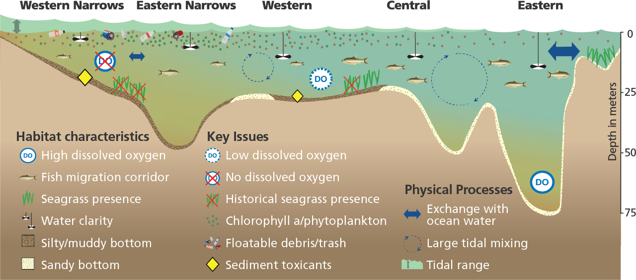
Long Island Sound is an estuary located between the southern shore of Connecticut and the north shore of Long Island, New York. It is influenced by the tides, with a large exchange with ocean water in the east and minor exchange with New York Harbor in the west. It has an average depth of 60 feet (20 meters) and a maximum depth of over 300 feet (100 meters). Both development and density of people increase from east to west along the Sound. There is intense development in the west, where the Sound meets the East River in New York City. People recreate in the water and along shorelines throughout the Sound. Long Island Sound varies in water quality (particularly dissolved oxygen) and depth (see figure below). There are strong gradients in tidal currents (highest in the eastern Sound) and tidal range (highest in the western Sound). Nutrient pollution fuels algal blooms in the Sound’s waters. When the blooms eventually die and decompose, they lead to a lack of dissolved oxygen for fish and shellfish. Water clarity is better in the east and worse in the west. Seagrasses, which have historically flourished throughout the Sound, now grow mostly in the eastern Sound.

Long Island Sound plays a significant role in the region’s economy
In the past, Long Island Sound supported abundant fisheries, such as oysters, scallops, and lobsters, and important salt marsh and seagrass habitat was widespread. These resources have been reduced as a result of environmental degradation from development, fishing pressure, and climate change. Nevertheless, the Sound is still a great place to live and play. Reducing pollution, protecting and restoring coastal habitats, and increasing our resiliency to climate change by protecting our coastal lands will only increase the value of this important resource.

Our actions on land impact our local waters

The Long Island Sound watershed is large and extends from New York City in the south, to Quebec, Canada in the north. The Connecticut River, which runs through Connecticut, Massachusetts, Vermont, New Hampshire, and northward into Canada dominates the watershed. The Housatonic and Thames Rivers in Connecticut are the next largest watersheds, while New York coastal watersheds are relatively small. With more than nine million inhabitants, what gets built in the watershed, what we apply on or what drains off the surrounding land can have consequences for Long Island Sound.
Overall, Long Island Sound is in good health, but there are still challenges to water quality. Humans cause the main impacts with development and agriculture. Stormwater runoff from streets, roofs, and parking lots carries pollutants like nitrogen, phosphorus, and sediment into the Sound.
Septic systems and fertilizers, pesticides, and herbicides used in agriculture, lawns, and landscaping also pollute the Sound. Some of the visible impacts to people and communities are beach closures in the summer due to high bacteria levels, and shellfish beds that have to be closely monitored for contamination.
Climate change is shifting fish species in the Sound

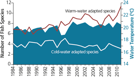
Climate change impacts in coastal waters include rising sea levels, increasing water temperatures, and more frequent and intense storms. Long Island Sound is already feeling the impact of changing temperatures in its cold-water and warm-water species. For example, fish species that prefer warm water, such as black seabass, butterfish, and summer flounder, appear more frequently in surveys of the Sound, whereas fish species that prefer cold water, such as winter flounder, Atlantic herring, and red hake, are slowly decreasing in number (see graph at right). Other climate change indicators, like marsh migration, have been observed in the Sound.
